Civil Drawings
Civil Engineering Drawings:
Designing the Framework for Modern Communities
Code Compliant
Drawings
Fast Turnaround
Time
USA Buildings
Code Standards
Permit-Ready
Packages
At Noblyn LLC, we provide comprehensive civil engineering drawing packages designed for rapid permit approval and accurate site execution. Every civil drawing set we produce is engineered to international standards — meeting the precise requirements of local planning authorities, municipal engineering departments, and site development regulations — so your project moves from submission to groundbreaking without unnecessary delays or costly revisions.
Civil engineering drawings are the foundation of any successful land development project. An incomplete or inaccurate civil package is one of the most common causes of permit rejection, site development errors, and costly construction rework. At Noblyn, we treat every civil drawing set as a precision engineering document — not a formality. Our civil engineers analyse site conditions, drainage patterns, topography, and utility infrastructure to produce drawings that are not only accurate on paper, but buildable in the field. From the cover sheet to the final grading plan, every sheet we deliver is reviewed for compliance and coordination before it leaves our hands.
Benefits
Our civil drawing service gives developers, contractors, landowners, and project managers a complete, permit-ready civil engineering package that addresses every aspect of site development — from the boundary fence to the stormwater outfall. We work closely with each client to produce civil drawings that are technically precise, fully compliant with local authority requirements, and perfectly coordinated with the architectural and structural drawings produced for the same project.
From compact residential lot developments to large-scale commercial site works and multi-stage land subdivisions, Noblyn delivers civil drawing packages that are built to the standard that planning authorities and municipal engineers expect — and that site crews can actually build from without ambiguity or re-engineering in the field.
- Full civil permit drawing sets
- Site-specific grading & drainage
- Stormwater & erosion control
- Coordinated with architectural
- Serving clients across the globe
- Utility layout & infrastructure
- Revisions included until approval
- Topographic & contour
Perfect Planning — Civil Engineering That Prepares the Ground for Everything That Follows
Civil engineering is where a project meets the land — and getting that relationship right requires more than accurate drawings. It requires a deep understanding of how water moves across a site, how earthwork volumes balance, how utility systems connect to municipal infrastructure, and how every civil element interacts with the buildings being constructed on top of it. At Noblyn, we bring that understanding to every civil drawing set we produce.
Approach
We begin with a detailed site analysis — reviewing topographic survey data, local authority requirements, drainage catchment conditions, and utility connection points. From there, our civil engineers design the complete site engineering solution — grading, drainage, utilities, and erosion control — and produce a fully coordinated civil drawing package aligned with your architectural and structural plans. Every set is reviewed internally for compliance and completeness before submission, so your civil permit application is as strong as it can possibly be on the first round.
Info Area
Site Development
- Residential lot development
- Commercial site development
- Subdivision & land planning
- Mixed-use site layouts
- Industrial site engineering
Drainage & Grading
- Grading & earthwork plans
- Stormwater management
- Detention & retention basins
- Erosion & sediment control
- Drainage channel design
Utilities & Infrastructure
- Water supply layouts
- Sewer & waste systems
- Dry utility coordination
- Road & pavement design
- Site lighting plans
Capabilities
- Cover sheets & project documentation
- Detailed site plans & layout drawings
- Grading plans & earthwork calculations
- Stormwater drainage & management
- Contour & topographic documentation
- Erosion control & sediment management
- Utility layout (water, sewer & power)
- Road & pavement design drawings
- Erosion control & sediment management
- Utility layout (water, sewer & power)
- Road & pavement design drawings
Work Process
- Site survey & topographic data review
- Local authority requirement analysis
- Grading & drainage system design
- Utility routing & layout planning
- Erosion & sediment control design
- Permit-ready delivery & revision support
Our Featured Work
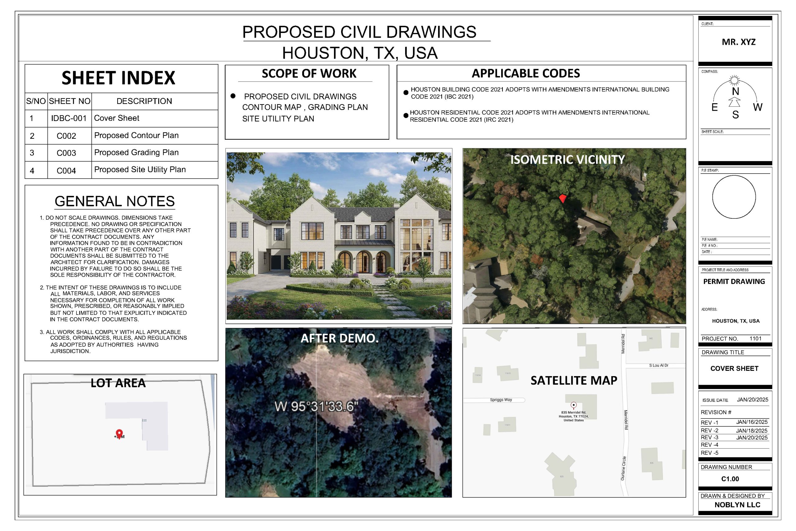
Cover Sheet & Project Documentation
Every Noblyn civil permit package opens with a professionally prepared cover sheet that establishes the complete identity and scope of the project for plan reviewers, municipal engineers, and site contractors. Our civil cover sheets include the project name and address, parcel identification and legal description, site area and proposed development summary, the complete drawing index listing every sheet in the set, applicable codes and standards references, general civil notes covering earthwork, drainage, and utility specifications, and a location map showing the site’s relationship to surrounding streets and infrastructure. A thorough, well-organised cover sheet signals to reviewers that the package behind it has been prepared with the same care — and that typically translates directly into a faster, smoother review process.
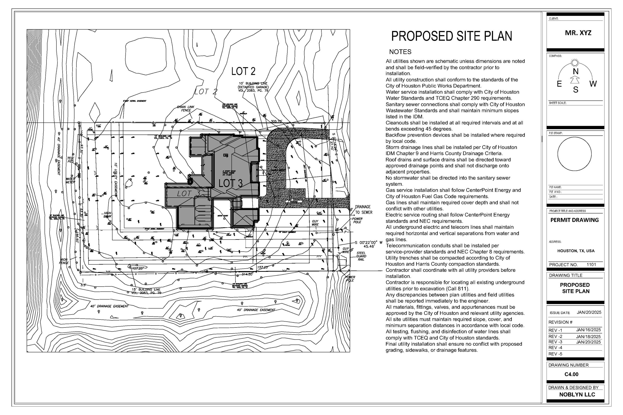
Proposed Site Plan
Our proposed site plans show the complete layout of the development on the land — the building footprint and setback dimensions, vehicle access points and internal circulation, parking layouts, pedestrian pathways, landscaping zones, site boundary dimensions, and all proposed civil infrastructure. Every site plan is drawn to scale from the surveyed property boundaries and cross-checked against zoning setback requirements, lot coverage limits, and floor area ratio restrictions before submission.
For commercial and multi-unit residential developments, our site plans also show ADA-compliant accessible routes, fire access lanes, trash enclosure locations, bicycle parking, and all other site elements required by the local planning authority. The proposed site plan is often the first sheet a plan reviewer turns to — and ours are drawn with the clarity and completeness that makes that first impression count.
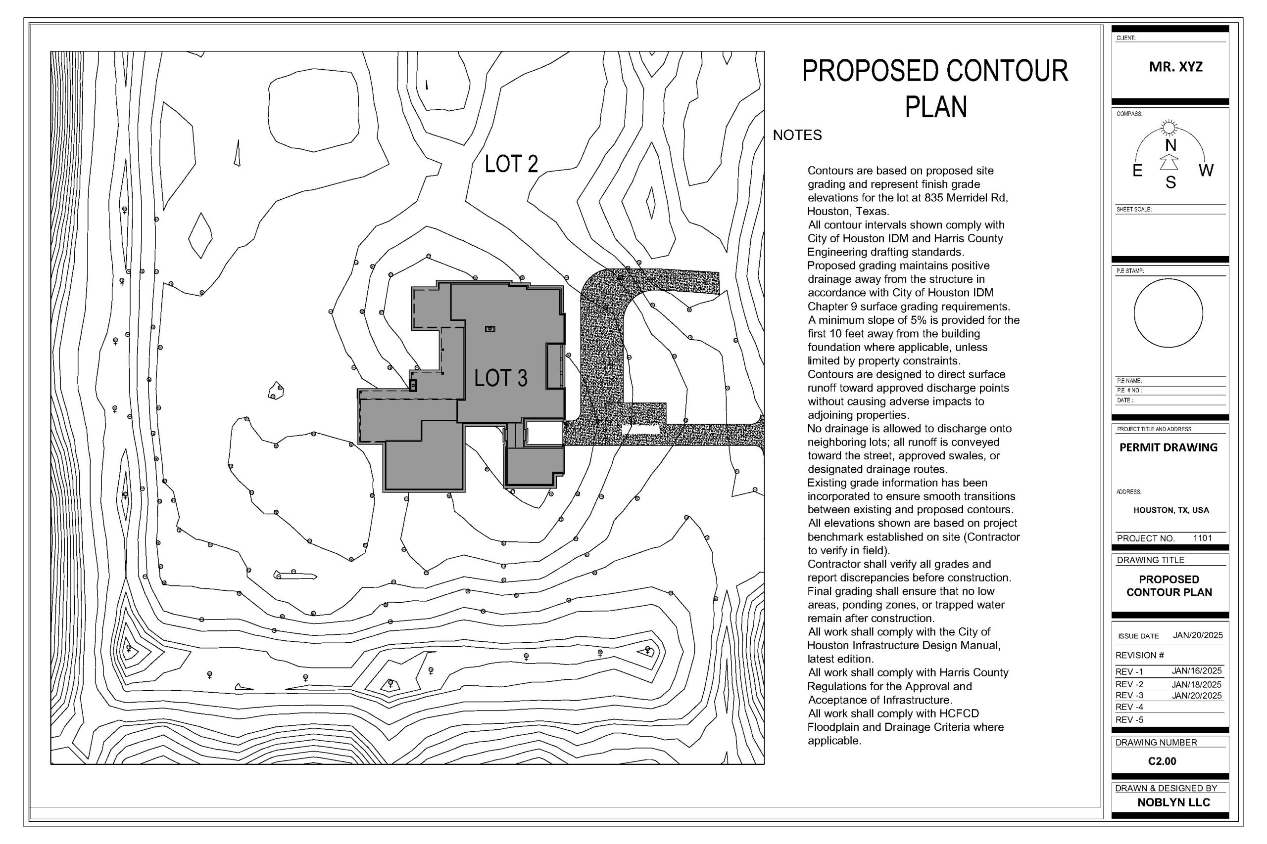
Proposed Contour Plan
Our contour and topographic drawings document the existing and proposed ground surface elevations across the site in accurate detail — showing existing contours from the survey, proposed finished grade contours after earthwork, spot elevations at critical points including building pads, pavement edges, drainage inlets, and property corners, and the relationship between existing and proposed grades along all boundaries and easements.
Contour plans are essential for verifying that the proposed grading design drains water away from buildings, stays within cut-and-fill balance targets, and meets the local authority’s requirements for finished grade relationships to adjacent properties and public rights-of-way. Our contour drawings are produced with a contour interval appropriate to the site’s topography and the level of detail required by the reviewing authority — and are always coordinated directly with the grading plan and drainage design to ensure complete consistency across the civil set.
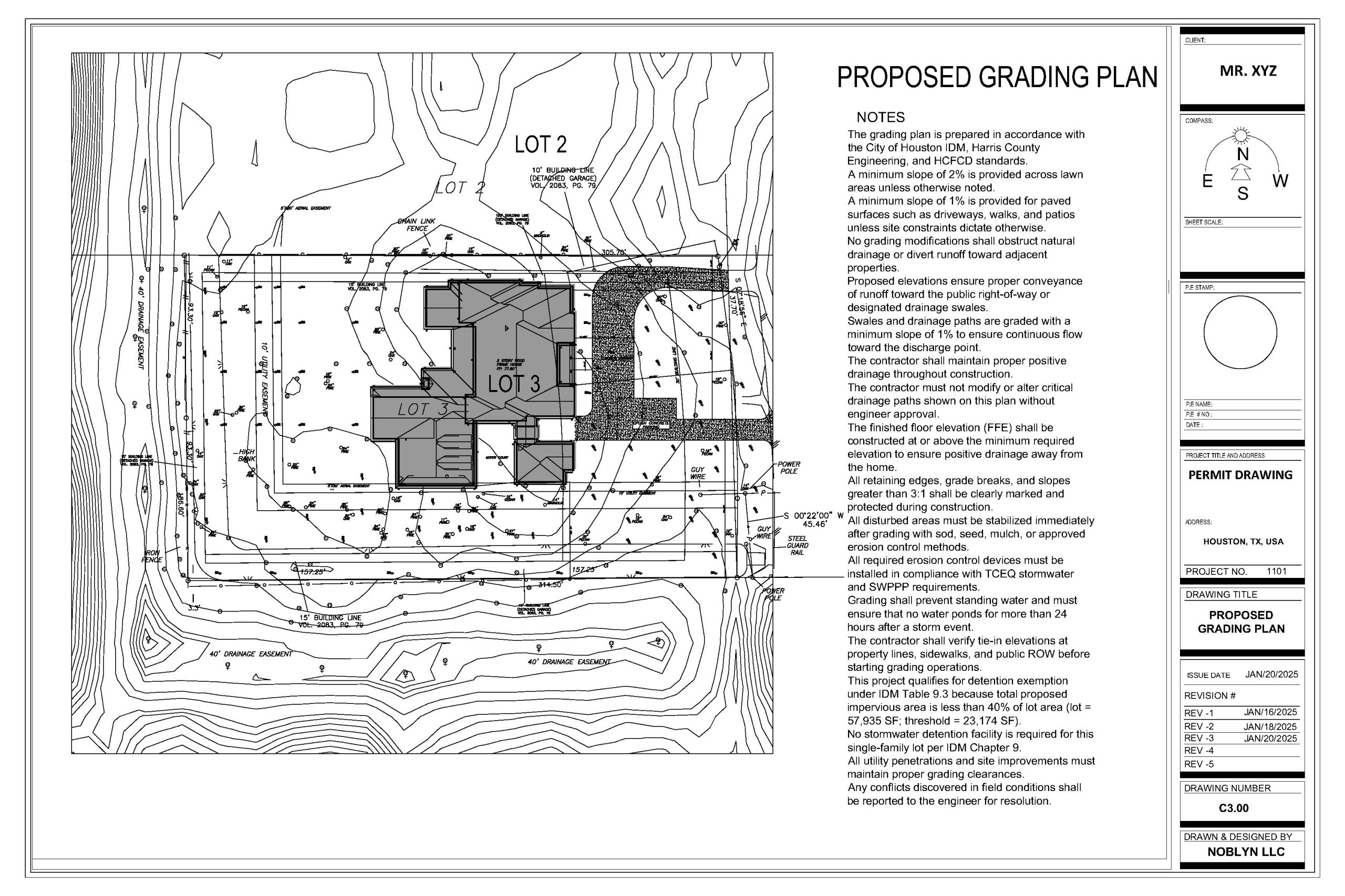
Proposed Grading Plan
Grading is where civil engineering directly shapes the construction experience — and a well-engineered grading plan is one of the most valuable documents in any civil permit set. Our grading plans show the complete earthwork design for the site: finished pad elevations for all buildings, pavement and hardscape grades, drainage swales and their gradients, retaining wall locations and heights, cut and fill areas with volume calculations, and all spot elevations required to confirm the site drains correctly under all rainfall conditions.
We design every grading plan to direct stormwater away from building foundations, toward designated collection points, and ultimately to the approved discharge location — whether that is a public storm drain, an on-site retention basin, or a natural drainage course. Our grading designs comply with local grading ordinance requirements, including maximum slope ratios, minimum drainage gradients, and setback distances for graded slopes from property lines and structures.
Earthwork volume calculations are included with every grading plan, allowing contractors to accurately estimate cut-and-fill quantities before mobilising equipment — reducing surprises in the field and keeping site preparation budgets on track.
Have Some Questions?
We Can Help!
A complete Noblyn civil drawing set typically includes a cover sheet and general notes, a proposed site plan showing building layout and site elements, a topographic and contour plan showing existing and proposed grades, a grading plan with earthwork calculations and spot elevations, a stormwater drainage and management plan, an erosion and sediment control plan, and a site utility layout showing water, sewer, and dry utility connections. Additional sheets such as road design, pavement sections, retaining wall details, and detention basin design are included where required by the project scope and local authority.
Many residential projects — including new home construction, ADUs, additions, and land subdivisions — require civil drawings as part of the permit application. Requirements vary by jurisdiction and project size, but most authorities require at minimum a site plan and grading plan for any project that involves earthwork or changes to existing drainage patterns. We review your specific project and local requirements and advise exactly what civil sheets are needed for your submission.
Yes — and this coordination is critical. Building pad elevations in the civil grading plan must align with finished floor elevations in the architectural drawings. Foundation depths in the structural drawings must be consistent with the graded site elevations in the civil plan. When Noblyn handles your complete drawing package — architectural, structural, MEP, and civil — all of this coordination happens in-house, eliminating the discrepancies between trades that commonly cause permit delays and field rework.
Our civil drawings address the full range of stormwater requirements imposed by local authorities — including surface drainage grading, storm drain pipe systems, inlet and outlet structures, retention and detention basin design, low-impact development (LID) features such as bioretention and permeable paving, and hydromodification compliance where required. We calculate pre- and post-development runoff rates to confirm compliance with local stormwater management standards and produce the drainage report documentation required to accompany the civil permit submission.
Yes. All Noblyn civil drawing packages include full revision support through the permit approval process. Municipal engineers and planning authorities frequently issue correction comments on civil submissions — particularly regarding drainage calculations, grading slopes, and utility connections. We address all plan check comments promptly and resubmit until your civil permit is approved, at no additional charge for revisions.